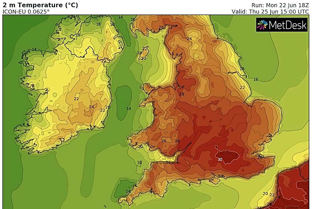
The UK’s official weather forecasters say temperatures in Sussex between now (June 23) and the end of the month are set to reach unusual highs.
According to the Met Office, temperatures will climb at least into the high twenties and possibly the thirties from Wednesday (June 24) onwards.
Nights are also predicted to be warm, with temperatures in the mid-to-high teens during the hours of darkness.
The Met Office’s chief forecaster Dan Suri said:
“We quite often see warm, southerly air from the continent bringing these high temperatures to the UK in summer.
“However this week, the air across the UK has arrived from the Atlantic.
“This Atlantic air will descend and warm up as it moves across the UK and this in combination with clear skies and strong late-June sunshine, we’re seeing temperatures rise.”
But forecasters added there was an increasing likelihood of thunderstorms arriving at the end of the heatwave.
Detailed forecasts using a combination of weather models showed temperatures in the centre of Sussex reaching 29°C on Wednesday and 30°C on Thursday, before slightly cooler temperatures on Friday, and colder air arriving to end the heatwave by Saturday.
For the month of June, the weather records to look out for were both set during the great drought of 1976 (which followed another dry year in 1975).
They include the highest UK maximum temperature of currently 35.6 Celsius (set at Mayflower Park, Southampton on 28th June 1976).
The highest UK minimum temperature, overnight, recorded in June is currently 22.7 Celsius, recorded in Ventnor Park on the Isle of Wight on 28th June 1976.


 Appeal Following Serious Collision In Portslade
 Boy, 15, Charged With Two Counts Of Attempted Murder
 Meet The Southern Train Driver Magistrate Delivering Justice In Sussex
 Witnesses Sought Following House Fire In Eastbourne
 University Of Brighton Recognised As Top Sports Education Provider
 Shoreham Harbour RNLI Opens Recruitment For Boat Crew Volunteers
 Eastbourne man admits stalking woman in Hailsham
 CCTV Appeal After Luggage Stolen From Gatwick
 Appeal After Boy Seriously Injured In Firle Collision
 Boy Charged After Knife Incident On Brighton Bus
Comments
Add a comment