


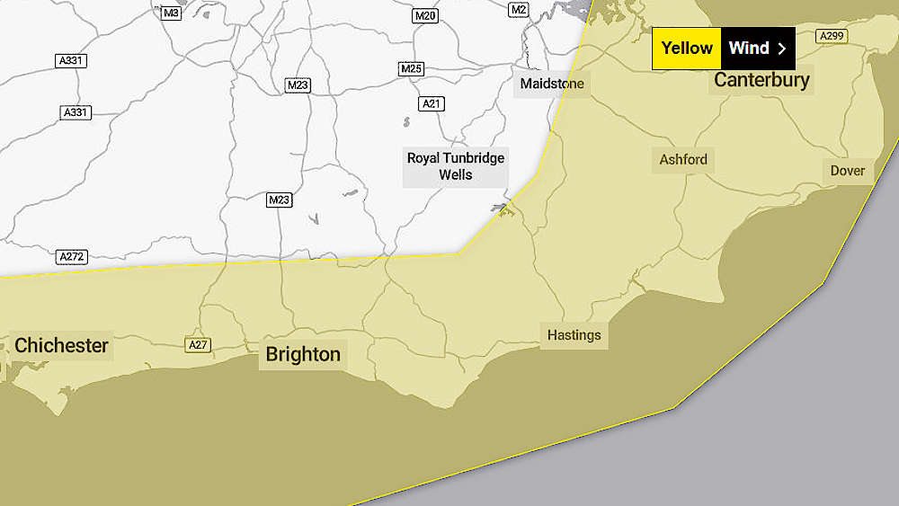
An official warning of high winds for all southern parts of Sussex is in place this morning and this afternoon.
Met Office forecasters said that Storm Gerrit is likely to bring gusts of up to 70 miles-per-hour in exposed coastal areas today, with more widespread gusts of between 50 and 60 mph.
Meterologists described the phenomenon bringing the gusts as a "deepening Atlantic low pressure system", which is due to bring widespread winds and heavy rain to much of Britain, but with the most serious hazard in Sussex being high winds.
The weather warning remains in place until 6pm today, December 27.
Britain's official forecasting service said people in the More Radio area could expect possible delays to road, rail, air and ferry transport.
There is also the likelihood of sea fronts and coastal communities being affected by spray or large waves.
A Met Office spokesperson said:
"Give yourself the best chance of avoiding delays by checking road conditions if driving, or bus and train timetables, amending your travel plans if necessary.
"People cope better with power cuts when they have prepared for them in advance.
"It’s easy to do; consider gathering torches and batteries, a mobile phone power pack and other essential items.
"If you are on the coast, stay safe during stormy weather by being aware of large waves.
"Even from the shore large breaking waves can sweep you off your feet and out to sea.
"Take care if walking near cliffs; know your route and keep dogs on a lead. In an emergency, call 999 and ask for the Coastguard."
Most weather prediction models currently show a further storm system due to enter Sussex on Saturday 30th December, with winds peaking in the early afternoon.
 £9,000 Available For New Community Orchards In Chichester District
 Sports Infrastructure Funding To Improve Outdoor Facilities In Sussex
 Appeal For Witnesses After Pedestrian Hit By Cyclist In Brighton
 Collaborative Working To Secure Future Drinking Water For Lewes, Eastbourne And Newhaven
 Sussex Boy Ravi, 9, Collects Prestigious British Citizen Youth Award
 East Sussex ‘Support Into Work’ Project Helps Refugees Secure Work And Training
 Man Jailed For Series Of Burglaries In Brighton And Hove
 Thousands Get Set To Run Beachy Head Marathon
 Man Arrested Following Report Of Armed Robbery In Berwick
 Local School Raise Money For RNLI After Water Safety Presentation